


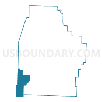
Valley Voting District, Madison County, Arkansas
About
Outline

Summary
| Unique Area Identifier | 527244 |
| Name | Valley Voting District |
| County | Madison County |
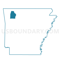
| State | Arkansas |
| Area (square miles) | 36.74 |
| Land Area (square miles) | 36.56 |
| Water Area (square miles) | 0.18 |
| % of Land Area | 99.52 |
| % of Water Area | 0.48 |
| Latitude of the Internal Point | 35.85048270 |
| Longtitude of the Internal Point | -93.91822310 |
Maps

Graphs
Select a template below for downloading or customizing gragh for Valley Voting District, Madison County, Arkansas


Neighbors
Neighoring Voting District (by Name) Neighboring Voting District on the Map
- Bidville Voting District, Crawford County, AR
- DURHAM Voting District, Washington County, AR
- J P Dist 3-C, Franklin County, AR
- Mill Creek Voting District, Madison County, AR
- REED Voting District, Washington County, AR
- White River Voting District, Madison County, AR
Top 10 Neighboring County Subdivision (by Population) Neighboring County Subdivision on the Map
- Durham township, Washington County, AR (907)
- Mill Creek township, Madison County, AR (610)
- Valley township, Madison County, AR (517)
- White River township, Madison County, AR (248)
- Reed township, Washington County, AR (230)
- Bidville township, Crawford County, AR (60)
- Morgan township, Franklin County, AR (18)
Top 10 Neighboring Unified School District (by Population) Neighboring Unified School District on the Map
- Huntsville School District, AR (14,572)
- West Fork School District, AR (5,446)
- Elkins School District, AR (5,032)
- Mountainburg Schools, AR (4,733)
Top 10 Neighboring State Legislative District Lower Chamber (by Population) Neighboring State Legislative District Lower Chamber on the Map
- State House District 89, AR (35,559)
- State House District 87, AR (30,579)
- State House District 90, AR (29,000)
- State House District 84, AR (25,531)
Top 10 Neighboring State Legislative District Upper Chamber (by Population) Neighboring State Legislative District Upper Chamber on the Map
- State Senate District 7, AR (93,757)
- State Senate District 3, AR (87,143)
- State Senate District 2, AR (83,273)
Top 10 Neighboring 111th Congressional District (by Population) Neighboring 111th Congressional District on the Map
Top 10 Neighboring Census Tract (by Population) Neighboring Census Tract on the Map
- Census Tract 101.05, Washington County, AR (8,065)
- Census Tract 201, Crawford County, AR (5,956)
- Census Tract 9603, Madison County, AR (4,895)
- Census Tract 111.03, Washington County, AR (4,012)
- Census Tract 9501, Franklin County, AR (3,832)